Florida COVID Action
A community-based approach to mapping coronavirus, built from existing and newly created data feeds, which can all be found in my data library. Click here to see the see the website (dashboard is no longer active as of June 2021).
The COVID Monitor
With the help of Google and FinMango, I co-founded the nation’s only data warehouse for COVID-19 in K-12 schools. Our project expanded to every district and state reporting COVID-19, investigated anonymous reports received from those areas hiding COVID-19 cases, and confronted some of the most dangerous anti-science propaganda during the pandemic.
Florida’s COVID-19 Data and Surveillance Dashboard.
My signature project during my time at the Florida Department of Health. From beginning to end, I was lone data manager and published for the state’s public-facing pandemic data systems and dashboard. FDOH stopped reporting in June 2021 and removed the dashboard and all of the public data feeds I built. As such, the site is no longer live.
While under my management, the FDOH dashboard was considered the “gold standard in data transparency and communication: during the COVID crisis.

Hurricane Michael: The Florida Department of Health’s Response to the Great October Storm (storymap)
My award-winning and interactive presentation of the FDOH’s response to Hurricane Michael (2018). I joined FDOH just a week before Hurricane Michael devastated the Florida panhandle, but with my previous experience in disaster response was able to play an integral role in the planning and recovery from the hurricane.
Please note: After my departure from DOH, a former supervisor erroneously gave himself unearned credit for the project.
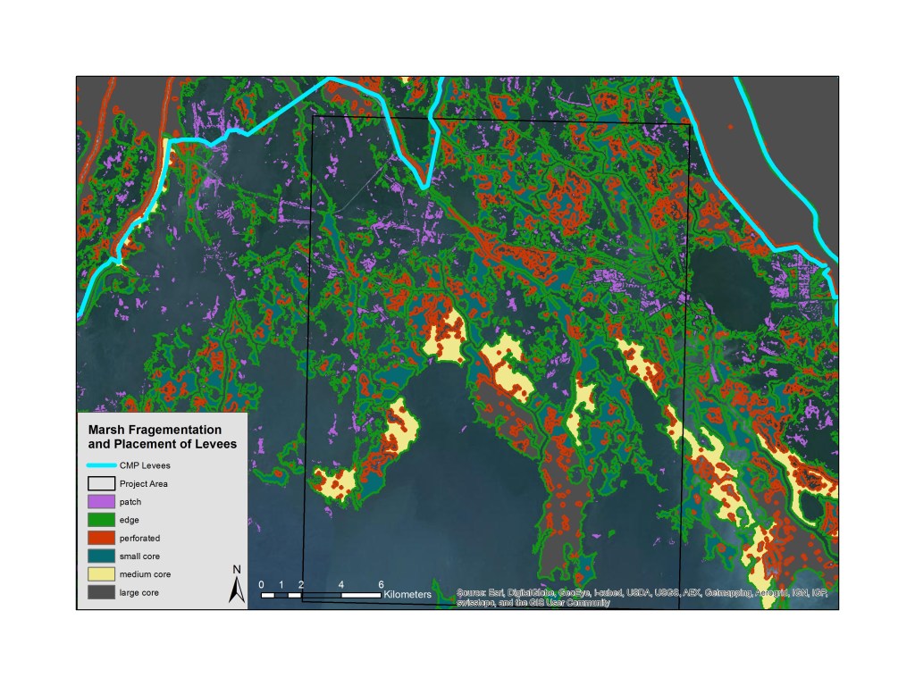
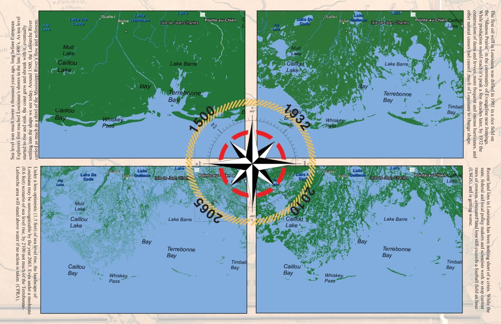
Mapping land loss and history in the Pointe-au-Chien Bayou of Terrebonne-Lafourche parishes, Louisiana.
Video: The Magic Trick of the Century!
You almost won’t believe it until you’ve watched it several times. In the last century, the area around Terrebonne Bay, Louisiana (often referred to as Interior Lafourche), has flipped from being 90% land (1916) to 90% water (2016).
This video shows how quickly and dramatically the landscape of south Louisiana changed to accommodate the oil, gas, and Sulphur mining operations that fragmented large areas of marsh, and triggered and exacerbated subsequent land loss in the decades following. The communities who lived in the area migrated northward as the seas and surge ate away at the marsh.
Today, all but a few close-knit communities and a handful of Native American tribes have abandoned the once prosperous marsh lands in search of safety and security farther from shore. For them, it’s a century-long trick with no magic.
Web Map: A Ghost Story: The Consequences of a Century of Development
Click here to launch map.
Industrial production, storms and hazards, and large-scale engineering of waterways have caused cascading impacts across nearly every part of the Pointe-au-Chien bayou. While local, state and federal agencies scramble to stall the ever-growing problems related to climate change, the thoughts and ideas of the communities living through it seem to go unanswered. With no scientists or lobbyists at their disposal, the tribe needed a way to show planning officials all the knowledge they had about the area, and provide critical data as to how their knowledge fits into the large environmental programs. I teamed up with tribe-appointed community members to survey the traditional ecological knowledge (TEK) of the changes to the marsh from first-hand accounts.
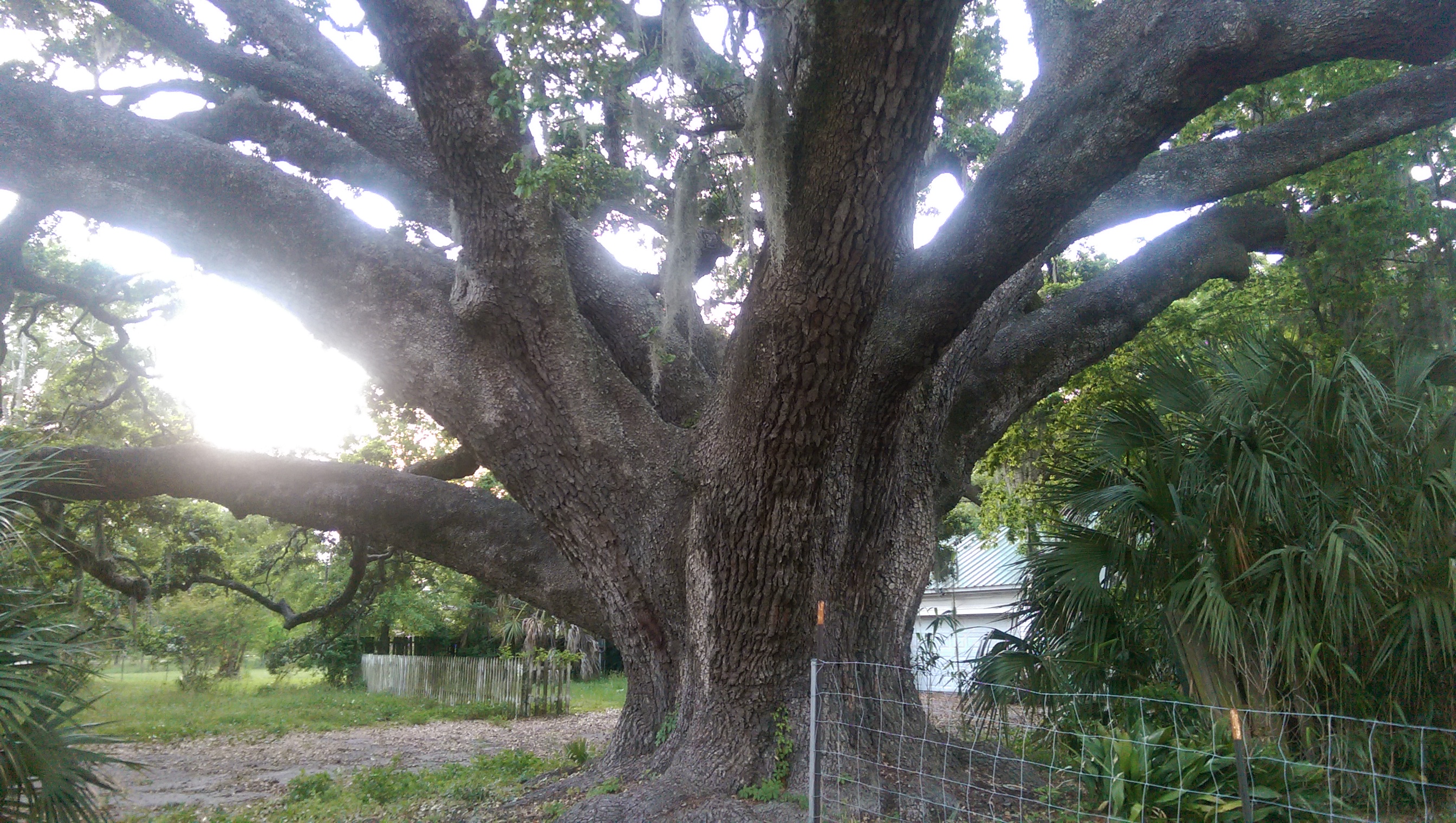
Interactive Mapping of Ancient Trees
Click here to launch the web map application (ArcGIS Online)
The project originated from an interest in the collective age of the southeast’s oldest and largest trees, with a focus on the Southern Live Oak, but also including the bald cypress and other species. The hope of this project is that a heightened awareness of the years these trees have survived may lead to citizen advocacy in protecting their stability. The interactive mapping application allows for users of various social media sites to upload and add their own photos of ancient trees, in addition to providing navigation for those interested in visiting the trees and a catalog of the estimated ages of each.
Video Projects
The above video was one I produced while working for Sea Grant, part of a larger series I had planned as a “crash course” in GIS that could be taken in pieces or in sequential order. I am currently developing similar videos on this theme, and hope to complete them in the next year.
Video: The Magic Trick of the Century!
You almost won’t believe it until you’ve watched it several times. In the last century, the area around Terrebonne Bay, Louisiana (often referred to as Interior Lafourche), has flipped from being 90% land (1916) to 90% water (2016). This video shows how quickly and dramatically the landscape of south Louisiana changed to accommodate the oil, gas, and sulphur mining operations that fragmented large areas of marsh, and triggered and exacerbated subsequent land loss in the decades following. The communities who lived in the area migrated northward as the seas and surge ate away at the marsh. Today, all but a few close-knit communities and a handful of Native American tribes have abandoned the once prosperous marsh lands in search of safety and security farther from shore. For them, it’s a century-long trick with no magic.
Drone Footage of Pointe-au-Chien Bayou, Louisiana
Drone footage of the bayou on and near the twin canals that cut through the Pointe-au-Chien (also Pointe aux Chenes) Bayou, just south of the American Indian community of the Pointe-au-Chien Indian Tribe.
Featured on TheNewshouse.com, about the first-ever EcoHouse on campus. The EcoHouse project is a program designed to give students the opportunity to live more sustainable lifestyles while at college, something the residents of the EcoHouse say is a hard thing to do. From the article, ” The amber glow coming from the dichloromethane bottle in the living room barely lights the space enough to read. The bottle is filled with old Christmas lights, dug out from the neighbors’ trash. It’s one of Gavin Okoniewski’s favorite parts of the house. “We’ve been trying to do this project basically on no money and very little supplies — things we find in the Dumpsters or what we can find for free on Craigslist,” said Okoniewski, a junior at the State University of New York College of Environmental Science and Forestry.”
Working with the Onondaga Earth Corps, the Rosamond Gifford Zoo, the Carousel Mall, the Syracuse Center of Excellence and others, I wrote, directed, produced, filmed and edited two videos under the Onondaga County “Save the Rain” program on some of the reasons why Syracuse save’s the rain. I am also in the video (the only blonde). Both videos were written, shot and edited in three weeks, collaborating with more than two dozen people.
This is the second in a series of videos I made for Onondaga County’s Save the Rain program. Working with the Onondaga Earth Corps, I directed and edited videos on five different types of green infrastructure to make six videos: a shorter piece including all the kinds of GI (link above) and a longer, more in-depth video of each type of GI (coming soon).
Posters and Graphic Design


Southern Climate Impacts Planning Program (SCIPP – A NOAA RISA Program) Products (click the title link to see the full-resolution product):

Climate Change in Arkansas
Climate Change in Louisiana
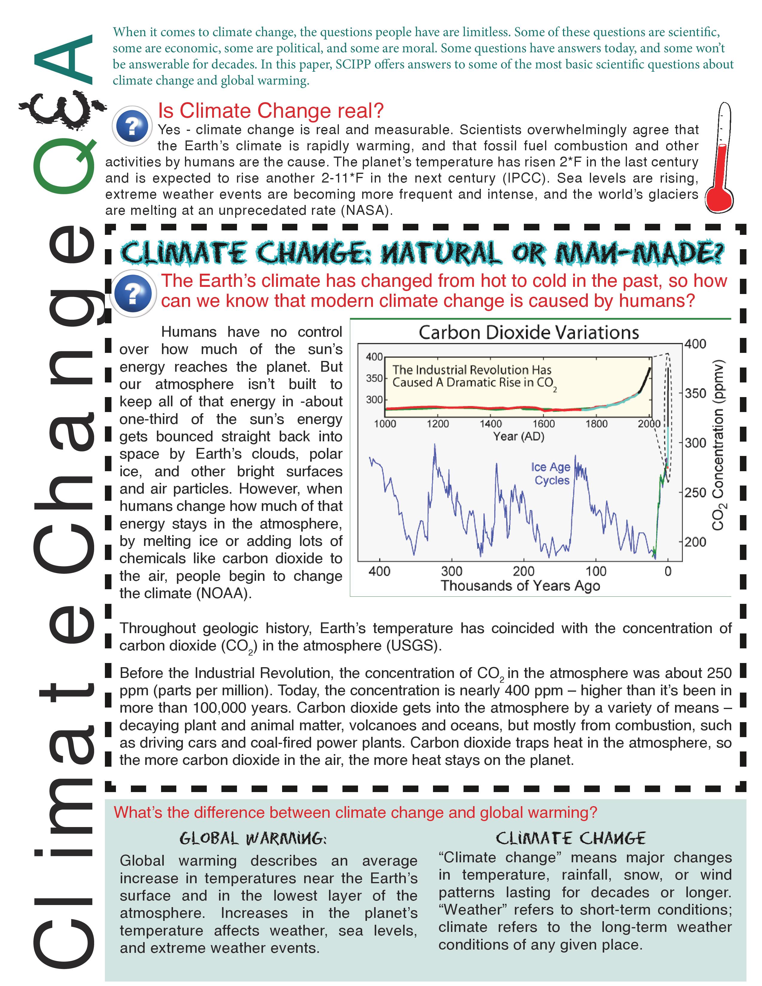
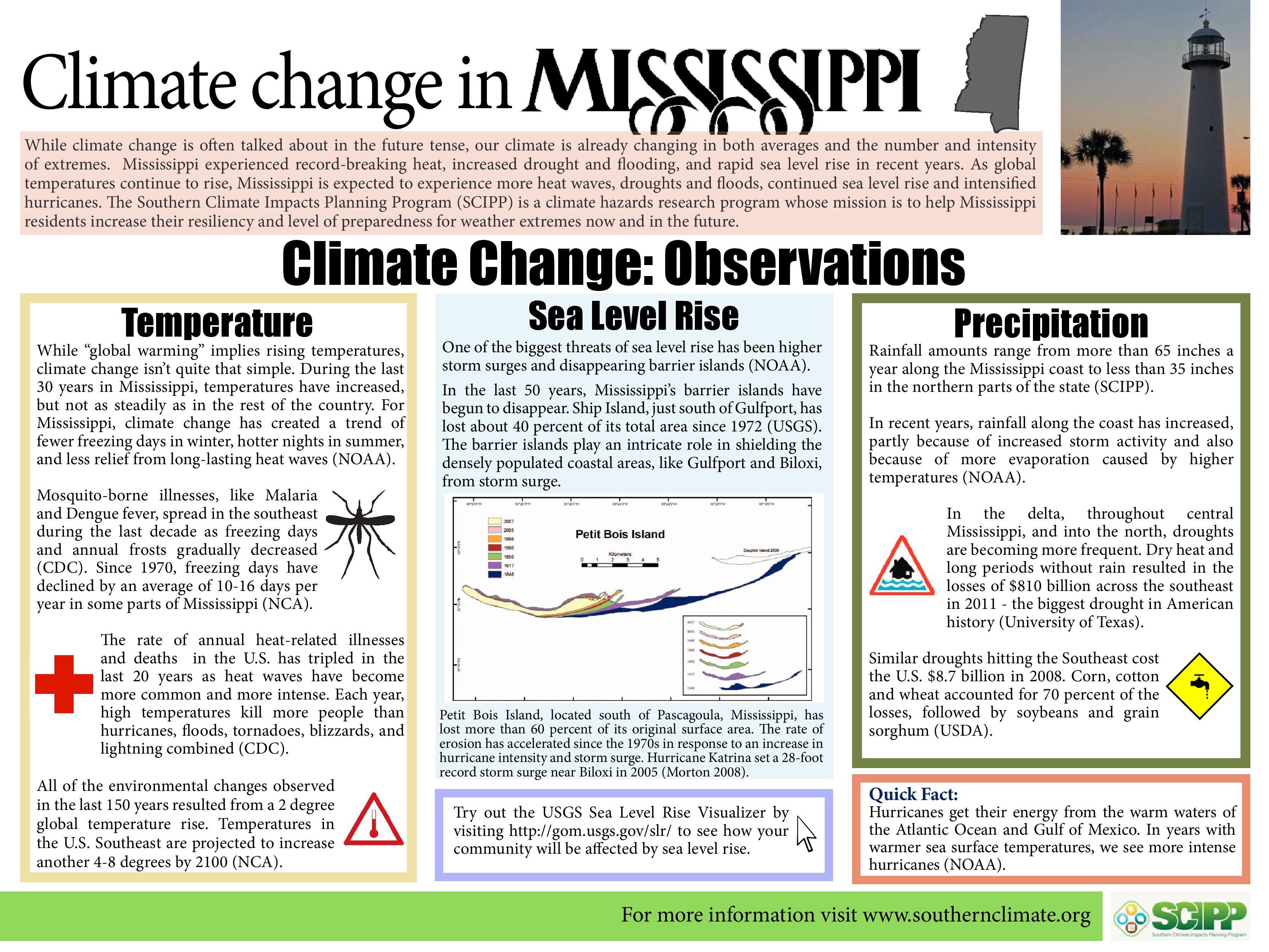
Climate Change in Mississippi
Climate Change in Oklahoma
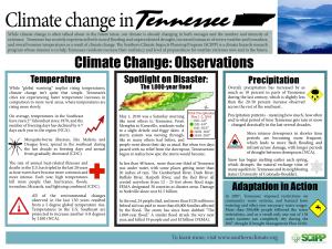
Climate Change in Tennessee
Climate Change in Texas


Syracuse Center of Excellence in Energy and Environmental Systems Products:


Save the Rain Postcard
Espanol rain brochure
SyracuseCoE Composting Guide
Course-related Projects and Maps
Tabloid Magazine Spread: “Killing U.S. Softly- Mapping Preventable Death in America”


